Pilckem Ridge WW1 (id:#64576)
Pilckem, Belgium
1915-04-22 (1 other)
GWASL #115: Kitchener's Wood (GWASL 15: Vimy Ridge and Beyond)
Designer: Unknown
Starter kit scenario?: Deluxe scenario?:
Balance:
GermanFrench
Overview:
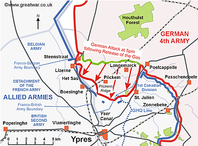
After three attempts to blow the gas cloud across the sector held by two French divisions in the northern part of the Ypres Salient, the German infantry attack on the sunny spring afternoon of 22nd April made significant advances into Allied held territory. Most of the French territorial and Algerian troops not immediately asphyxiated by the poisonous gas retired from the front line in confusion. The German infantry, following on behind the gas cloud at 5.15pm, successfully broke through the Allied front line. Within half an hour of the attack the German 52. Reserve Division in the centre of the attacking front had covered 3 to 4 kilometres of French-held ground and had reached its first objective - the high ground of Pilckem Ridge - by the village of Pilckem.Attacker: German (52nd Reserve Division)
Defender: French (Algerian 45th Division)
7.5 turns
Players: 2 OBA: Both Night: No| Unit Counts: |
| Squads: A:21.0 D:16.5 |
| AFVs: A:0 |
| AFVs: D:0 |
| Guns: A:2 D:2 |
| Misc Rules: |
| Map Board(s): |
| Publication | Board |
|---|---|
| GWASL Great War 2: Blasted Woods | CH-M |
| GWASL Great War 2: Blasted Woods | CH-N |
| Overlays: |
Errata (source)
Players wanting to play this game/Request a match:
Scenario info
| Action | Date |
|---|---|
| Turuk Removed a map | 2024-05-07 19:55:52 |
| Turuk Modified the maps | 2024-05-07 19:55:41 |
| hoxson1 Modified the overview | 2021-08-24 01:39:14 |
| hoxson1 Uploaded an Image | 2021-08-24 01:32:00 |
| hoxson1 Uploaded an Image | 2020-01-05 16:47:07 |
| File | Description | User | Views |
|---|---|---|---|
| (ww1 germ-french.png) | Image | hoxson1 | 1121 |
| (gw germ counter.png) | Image | hoxson1 | 918 |
| (pilckem ridge battle.png) | Image | hoxson1 | 912 |
| Description | Uploaded by |
|---|
| Title | Author | Date |
|---|
| Description | Uploaded by |
|---|
Quick Map View
No Map available yet! Please create one, or upload a map image file...


